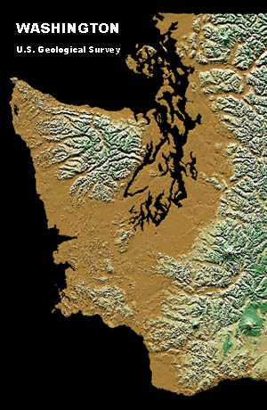
Click on the U.S. Geological Survey
shaded relief map of Washington State
above, or use this link to view the entire state.
It's a 2.1 Mb file (1050 x 700 pixels) and is slow to load.
Port Townsend, Washington 98368
48 Deg. 07 Min. 02 Sec. North Latitude (48.104012)
122 Deg. 45 Min. 33 Sec. West Longitude (-122.794457)

Jefferson County is unique.
It's one of Washington's largest with 1,805 square miles and one of the least populous with fewer than 25,000 residents. It's the only county whose borders include the Pacific Ocean, the Strait of Juan de Fuca, Puget Sound and Hood Canal. Its territory includes some of Washington's highest, driest, deepest and wettest: Mount Olympus at 7,695 feet; the Victorian Seaport of Port Townsend with only 18 inches of annual precipitation; the Hoh Rain Forest with 200 inches of rain a year; saltwater depths greater than 600 feet; and, with more than 50, the most glaciers west of the Cascades. Only Alaska offers more expansive and spectacular wilderness. Millions visit Jefferson County every year on their way to adventure and recreation in Olympic National Park, Olympic National Forest and state and county parks.
Jefferson County's Discovery Bay was the site of Captain George Vancouver's historic first landing on America's northwest coast more than 200 years ago. It was Washington's western wilderness and already 37 years old as a county when James Christie led the Press Expedition across unexplored mountains in 1889-90. Now, ultramarathoners and backcountry runners cover half the expedition's 100-mile route -- from modern trailhead to trailhead -- in a day. A century after the Press Expedition, the number of first-time explorers and regular visitors has continued to increase dramatically.
Every weekend, thousands of boaters, birders, kayakers, divers, campers, hikers, climbers, cyclists, hunters, skiers, sport fishermen and whale watchers discover adventure and recreation on the Olympic Peninsula -- along the ocean coast, at inland lakes, in forests and meadows, on trails and rivers and in the mountains. More than three-fourths of Jefferson County is taken up by Olympic National Park and the Olympic National Forest.
Distances that once took days or weeks of arduous effort to cover can now be driven comfortably in an hour. Families plan afternoon picnics in scenic groves that just decades ago were visited by only the hardiest hikers and most accomplished wilderness navigators. But for all its inviting accessibility and beckoning beauty the Olympic Peninsula is as wild now as it was centuries ago. Just a few yards from any footpath today's hiker can find the same challenges and dangers that confounded the Press Expedition, the same challenges that have inspired millions of visitors every year, and the same dangers that have proven deadly to the unwary and overconfident.
A trip plan can save your life! Pilots file flight plans with the Federal Aviation Administration and recreational boaters file float plans with the Coast Guard or friends. Leave a trip plan with a responsible person before venturing into the backcountry. Be sure to include the following information:
number(s) of vehicle(s) left at trailhead?
| Home | JSAR | Contact | Jefferson County | Ten Essentials |
| Trip Plan | Mission Planner | ARES/RACES |
| Washington SAR | Port Townsend Guide |
Contact Terms of Use Privacy Statement Notice and Disclaimer
Copyright © 2000 Dennis Cowals All rights reserved.