|
Forest Fire of 1845 Compiled by Leonard Whitmore, Siuslaw National Forest, Hebo Ranger District, 1986 The north half of Lincoln and south half of Tillamook counties were engulfed by flames, destroying most of the old growth timber of the area. Forty-nine years after this fire the editor of the Sheridan Sun journeyed to Woods. As he traveled through the Coast Range, he noticed that as far as the eye could see in all directions, stood dead and charred old growth snags. Because of the vast expanse of a totally destroyed forest that was once so green and majestic, he became curious about its origin and decided to look into its history. While at Woods he met Peter Belleque, a commercial fisherman, who was knowledgeable of pioneer events and threw light upon the great forest conflagration of 1845, not hitherto published. Mr. Belleque was born in 1836 near Champoeg of a French father and Indian mother. The fire's origin was near Champoeg when he was nine years of age. He related that several years before 1845, an English sailing ship entered the Columbia River. On board was Mr. Johnson who was the ship's cook. Being dissatisfied with his occupation he deserted ship at first opportunity and traveled down the Willamette Valley to near the present community of Champoeg. Here he took up a land claim and immediately started clearing his land of brush and logs. The summer of 1845 was unusually hot and dry. Springtime was short of rain causing all vegetation to mature early and dry up by the first of July. Most of the Willamette Valley was covered with tall grass. The Indians for centuries periodically burned portions of the valley to kill off the brush and encourage the growth of grass. The new grass growth made ideal forage for the numerous deer and elk that inhabited the valley. This was made to order for the Indians who depended upon the larger game for their livlihood. Mr. Johnson thought conditions were just right to burn the debris from his cleared land. He touched it off and succeeded in getting a good burn, but unfortunately a west wind blew a path of flames across the Willamette Valley into the Coast Range. The wind direction suddenly changed into a hot, dry east wind. This fanned the flames into a frenzy, making an end run around the previously burned path, blazing westward across the valley toward the Coast Range. The hot wind fanned it day and night and the whole valley was filled with a billowing pall of smoke. So dense did the smoke become that the settlers were forced to eat their midday meal by candlelight. Many of the settlers felt the end of the world was at hand. The flames reached the Coast Range covered by a thick forest. With this added fuel, the flames lashed out to the north, west and south. At this point, let's see what is in the path of this conflagration. Old growth virgin timber, 400 to 600 years old, extended from the Willamette Valley to the ocean beaches and indefinitely north and south. At this early date of 1845 there were no settlers west of the Coast Range. The only inhabitants were small tribes of Indians, located at bays or where sources of water flowed into the ocean. Such tribes were located on Siletz Bay, Neskowin Creek, Woods, Sandlake and Netarts Bay. Several years before 1894, Peter Belleque interviewed Dick Harna, retired on the Siletz Reservation, about the fire in Tillamook County. Harna was the chief of the Nestuccas living near the present town of Woods. Harna, according to Belleque, gave a vivid description of the fire, as witnessed by himself. He and a portion of his tribe were encamped on the Big Nestucca River, four miles upstream from the present site of the village of Woods. For several weeks, according to the Indians, there had been a great deal of smoke. Each day it grew denser and filled the Indians with new alarm. Finally, one night the Nestuccas were awakened by a bright red glare in the eastern sky. By sunrise great flames were seen leaping skyward from the summits of the nearest hills. So rapidly did the flames approach that the terrified Indians had no time to gather up their belongings, but hastily jumping into their dugouts, paddled down the river to the ocean beach with all possible speed. Below Woods, about 1 1/2 miles is a sandspit between Nestucca Bay and the ocean where its greatest width is 1/2 mile. The bare sand afforded a safe refuge for Harna and his people for some weeks until a heavy rain put out the fire. Their only source of subsistence was fish. Paddling up the river to their haunts, gruesome sights met their eyes at every turn. Here and there piled up in groups were bands of elk and deer charred crisp; bear found nearly barbecued; and panthers, with their bodies in the water, showed their ghastly cooked heads. Another band of Indians retreated to Sandlake where they found safe assylum until the welcome rains. the Weekly Oregonian, August 31, 1894. Footnote: Old Peter Belleque (pronounced Blake), an emigrant from Canada, was originally named Pierre, but preferring an American name changed it to Peter. Two of his grandsons, Ernest and Peter, lived in the Cloverdale area all their lives. Pete is the only survivor at this date of May, 1986. The fire has two areas of historical significance. It's the first forest fire recorded in Oregon. Evidence of the remnants of thousands of snags killed by the great fire of 1845 can still be found, extending from Tillamook southward 60 miles to Newport and from the westward boundary of the Willamette Valley for 40 miles to the ocean beaches. This encompasses 1,500,000 acres, the largest area of old growth destroyed by a single forest fire in the United States. Siuslaw National Forest Hebo Ranger District 31525 Hwy 22 Hebo, OR 97122 Phone: (503) 392-3161 |
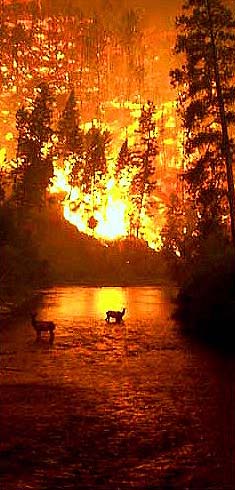
 Elk trapped by the Bitterroot Fire, Montana, August 6, 2000. Photo by John McColgan. In 2000, the combination of hot, dry weather and plenty of dry vegetation led to one of the most destructive forest fire seasons in U.S. history. By November, when winter snows helped extinguish the last fires, about 7.2 million acres had burned nationwide, nearly double the ten-year average. States hardest hit included Alaska, Idaho, Montana, New Mexico, Nevada, and Oregon. Foresters fear the drought could bring another record fire season to the West in 2001. | |||
|
YEAR 1845 1848 1849 1853 1865 1868 1933 1936 1939 1945 1951 1966 |
NAME The Great Fire Nestucca Siletz Yaquina Silverton Coos Bay Tillamook Bandon Saddle Mountain Wilson River/Salmonberry North Fork/Elkhorn Oxbow |
ACREAGE 1,500,000 290,000 800,000 482,000 988,000 296,000 240,000 143,000 190,000 180,000 33,000 44,000 | ||
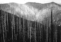
 The Tillamook Burn of 1933 killed almost 12 billion board feet of timber, enough lumber to build more than a million five-room houses. Three more fires, in 1939, 1945 and 1951, ravaged the same region, burning a collective total of 360,882 acres.  Now, a replanted second-growth forest is green again, and miles of trails west of Portland are open to hikers, mountain bikers, equestrians, motorcyclists and off-road vehicles. Tillamook State Forest OregonLive.com - Tillamook Trails US Forest Service Fire Pages USFS Outdoor Safety BLM Science & Technology Center National Interagency Fire Center PDX - National Weather Service National Fire Weather Page Oregon Fire Weather Forecasts Oregon Department of Forestry Oregon Climate Service Oregon Forest Resources Institute U.S. Drought Monitor Wildfire News | ||||