
|
Climbing Alaska's Mt. McKinley has been described alternately as a long walk in the snow, or as one of the most difficult high mountain ascents in the world, depending 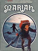 The Expedition
That Fell From The Sky on the route being climbed and conditions encountered along the way. Even in mid summer, conditions on North America's tallest mountain are arctic in character. During the two- to four-week ascent, most parties encounter temperatures ranging from + 70° to - 40° F. (+ 27° to - 40° C.). Winds in excess of 100 m.p.h. (160 k.p.h.) are not uncommon.  Individual storms sometimes last two weeks, making it imperative that climbers prepare for at least a month's climb on easier routes and as much as six weeks on difficult routes. Although nearly 3,000 climbers have stood on its 20,320-foot (6,194-meter) summit since the first ascent in 1913, none have treated the mountain casually. Over forty have died on its slopes. As on big mountains elsewhere, hidden crevasses have taken unnecessary lives. Climbers should always travel roped, no matter how easy the terrain appears. Expeditions planning to attempt Mt. McKinley must register at least two months in advance with the National Park Service and should complete all preparations before coming to Alaska, including arrangements for a radio and charter air transportation. Climbers should also plan on removing all their equipment and trash from the mountain.  West Buttress Westliche Stützmauer Le Contrefort de l'Ouest South Buttress Südliche Stützmauer Le Contrefort du Sud Muldrow Glacier Muldrow Gletscher Le Glacier Muldrow West Rib Westliche Rippe La Côte de l'Ouest Cassin Ridge Cassin Kamm La Crête Cassin Coming Soon Doug Scott & Dougal Haston's South Face Direct This map and the climbing descriptions can only serve as general guides to the five major routes on Mt. McKinley because of daily and seasonal conditions. On a big mountain, no guide or map can safely be substituted for good mountaineering judgement. Copyright © 2001 by Dennis Cowals. All rights reserved. Ice axe and rope logo copyright © 2001 by Dennis Cowals. Mountaineers edition copyright © 1981 by Dennis Cowals ISBN 0-89886-020-2. Original edition copyright © 1976 by The Alaska Alpine Company. |
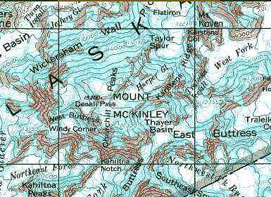
Mt. McKinley 1:250,000 scale - U.S. Geological Survey
Denali National
Park & Preserve
Mountaineering
Guidelines,
Regulations
& Information
Mountaineering in
Denali National Park
& Preserve
National Weather Service
Alaska Region
Denali National Park
Weather Forecast
Wind Chill Calculator
North to Alaska?
These friends
are good folks
to contact.
We've shared
many climbs,
rescues and
adventures
over the years.
Westliche Rippe - La Côte de l'Ouest
FIRST ASCENT: June 8 to June 19, 1959 by Jake Breitenhach, Bill Buckingham, Barry Corbet and Pete Sinclair. Beginning their climb from the normal landing area, the mountaineers moved up the Kahiltna Glacier to its intersection with the Northeast Fork. After working their way through numerous crevasse zones they reached the head of the glacier and gained the ridge leading to the West Rib by climbing a difficult ice couloir. Once on the ridge itself, the party had to surmount a pair of ice domes before reaching easier ground and the succession of rock ribs and couloirs leading to the summit ridge. After gaining the high ridge, the climbers followed the normal West Buttress Route to the South Summit. On the descent, they retraced their own tracks to the highest camp and then traversed west to join the West Buttres Route above Windy Corner.
POINT OF DEPARTURE: Southeast Fork, Kahiltna Glacier
ALTITUDE GAIN: 13,320 feet (4,060 meters)
ROUND TRIP DISTANCE: 24 miles (38 kilometers) via West Rib descent, 28 miles (45 kilometers) via West Buttress descent
TIME: 15 to 30 days
CRUX: Couloir between 11,100 and 12.300 feet
(3,383 and 3,749 meters)
SPECIAL EQUIPMENT: 3,600 feet (1,200 meters) of fixed line
and 12 snow pickets; 12 ice pitons; 40 rock pitons (mostly horizontals and small to medium angles)
ROUTE: From the landing area outside the park boundary at the 7,000-foot (2,194-meter) level of the Southeast Fork of the Kahiltna Glacier, proceed down glacier, west, to the junction with the main stream of the Kahiltna Glacier. Turn right, north, and proceed approximately 5 miles (8 kilometers) to the junction with the Northeast Fork of the Kahiltna Glacier.
Turn right, east, and proceed up the left center of the glacier through the crevasse zones for a distance of 3 miles (4.8 kilometers) to the base of the icefall at 10,000 feet (3,048 meters). Move up and left, north, through the icefall to the base of the eprominent couloir at 11,000 feet (3,383 meters).
Like the Japanese Couloir at the base of the nearby Cassin Ridge Route, this is the crux of the climb. Snow and ice in the couloir stand at an angle of 50 to 60 degrees. Fixed ropes may be anchored to snow, ice or rock as conditions warrant to safeguard the ascent to the base of the ridge at 12,300 feet (3,749 meters). As much as 1,600 feet (500 meters) of line may be needed for the couloir.
From an icy stance at the top of the couloir, continue upward along the ridge line over two prominent ice humps between 12,400 and 13,500 feet (3,779 and 4,115 meters) until the ridge widens out and the angle lessens. As much as 1,800 feet of fixed line may be needed to protect the route over the two ice domes, but the climbing is straightforward on ice and hard snow.
Above the second hump, the ridge broadens and movement becomes easier for one-half mile (1 kilometer) until the angle again increases at 13,900 feet (4,237 meters).
Still moving up the ridgeline, cross a bergschrund that bisects the slope at about 14,200 feet (4,328 meters), and climb difficult rock or an ice couloir which may require another 600 feet (200 meters) of fixed rope to gain a rocky terrace at 14,800 feet (4,511 meters). Mixed ground leads to 15,300 feet (4,663 meters) where the panorama of the West Buttress becomes visible. Pitches of rock and snow alternate until the ridge ends at a broad snow slope at 18,000 feet (5,486 meters).
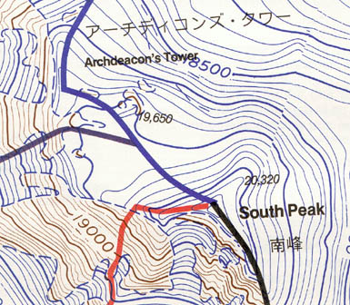
Mt. McKinley Summit 1:25,000 - adapted from U.S.G.S.
West Buttress West Rib Cassin Ridge South Buttress
The route continues up and to the left across the snow slope to the northernmost couloir which joins the West Buttress Route leading to the summit at the 19,400-foot (5,913 meter) level. From this point, the South Summit lies about one mile (1.6 kilometers) to the east across a shallow basin and up the final snow slopes.
Parties descending via the West Buttress Route generally begin the traverse across the high snow basin from the 16,000-foot (4,877-meter) level of the West Rib.
CAMPS: Nine or ten camps are normally made by parties climbing the West Rib Route.
Camp 1 7,000 ft. 2,134 m.
Camp 2 7,200 ft. 2,195 m.
Camp 3 7,800 ft. 2,377 m.
Camp 4 8,500 ft. 2,590 m.
Camp 5 9,600 ft. 2,926 m.
Camp 6 10,800 ft. 3,292 m.
Camp 7 12,300 ft. 3,749 m.
Camp 8 14,800 ft. 4,511 m.
Camp 9 16,500 ft. 5,029 m.
| South Buttress |
West Buttress | West Rib |